Outer Banks Faces Minimal Impact from Tropical Storm Helene
The Outer Banks and eastern North Carolina will likely experience minimal effects from Tropical Storm Helene. The storm is expected to strengthen into a major hurricane before making landfall along the Florida Panhandle on Thursday.
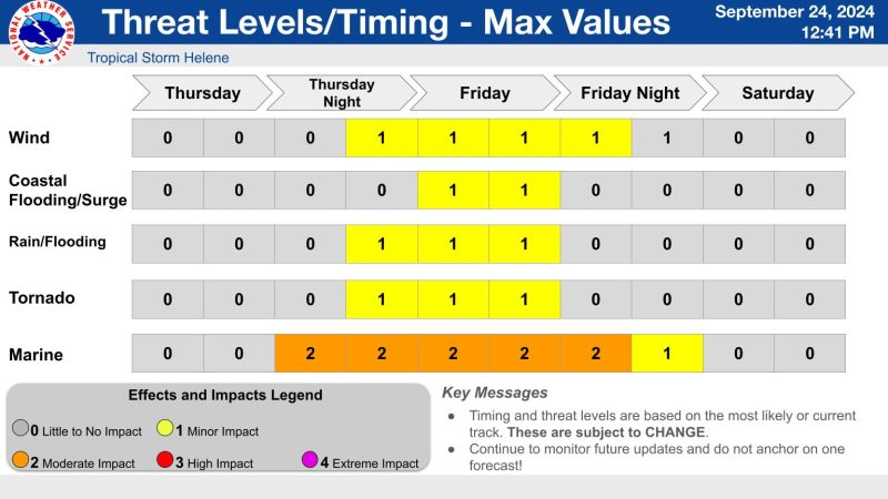
Despite the favorable forecast, eastern North Carolina could still see some rain. This rain may lead to flooding, as soils are already saturated. Additionally, a few thunderstorms and isolated tornadoes may occur, with gusty winds especially affecting southern coastal waters.
“While the current track would keep the most significant impacts to our west, this will be a large storm,” said forecasters from the National Weather Service’s Newport/Morehead City office. “We may still experience at least some impacts in Eastern North Carolina.”
Helene’s Projected Path
According to the National Hurricane Center, Helene could reach category 3 status with maximum sustained winds of 115 mph by Thursday. This will happen as the storm moves over warmer waters in the northeast Gulf of Mexico.
After landfall, Helene is forecast to move inland. As it travels through the southeast U.S., the storm will likely grow in size before heading over the Appalachians and into the Midwest.
Heavy Rainfall Expected
Heavy rainfall is anticipated over the mountains and Piedmont regions of North Carolina. The Outer Banks is expected to feel impacts from late Thursday night through Friday evening. Impacted areas include south of Cape Hatteras, along the lower Pamlico Sound, and below the Pamlico River.
Forecasters warn that the rapidly developing nature of the storm may lead to quick changes in timing and areas affected.
In the meantime, the Outer Banks will enjoy typical early fall weather on Wednesday. Expect mostly sunny skies and highs around 80 degrees. However, inland areas may experience more clouds and isolated showers.
Coastal Flood Advisory in Effect
A Coastal Flood Advisory remains in effect for the beaches through Wednesday afternoon. This advisory is due to persistent onshore flow, waves from an offshore low pressure system, and high tides from last week’s full moon.
Water levels could rise one to two feet above normal one to two hours before and after high tide, around 2 a.m. and 2:30 p.m. on Wednesday.
As winds shift on Thursday, elevated water levels in sounds and coastal rivers may cause localized flooding issues this weekend.